Sortino
“And now that I am left alone, I will go to the highest point of Roncisvalle and play the oliphant. May Carlo come with the main army to avenge.”
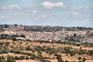
Sortino, ancient fief of Moncada and Eredia, had new life after the 1693 earthquake thanks to the barony of Gaetani, a family from Tuscany. The architecture of the city, similar to that of Palermo, was defined around the Quattro Canti, so much so that it soon became a valuable example of Sicilian baroque. Sortino is the northern gate of the Pantalica necropolis, from where you can access to admire the five thousand caves dug by generations of hominids to live in and later reused by the Pantalic civilization as tombs. In the center, the notable Chiesa Madre dedicated to San Giovanni Evangelista and the Chiesa di Santa Sofia and Maria Santissima del Carmelo stand out. Numerous are the noble palaces all in late Baroque style. A visit of the "Museo dell’Apicoltura tradizionale" and the "Museo dell’Opera dei Pupi" is recommended. The Puglisi family, puppeteers for five generations, are one of the prides of Sortino. Sortino, in addition to the lemon of Siracusa, is also famous for the aromatic honey of the Iblei mountains, exalted in ancient times even by Virgil and Ovid. An unforgettable excursion by MTB along the "Greenways della Pantalica e Valle dell’Anapo" following the track of the old railway line from Siracusa to Vizzini and Ragusa, until you reach Cassaro.
www.siracusaturismo.net | www.vivasicilia.com | www.comune.sortino.sr.it
The HUB in Sortino is interested in the "Valle dell'Anapo" route and is the start and end point of the route with the starting GATE located in Piazza Santa Sofia and the arrival POINT at the entrance to the Riserva Naturale Pantalica. The first stage leads to the POINT in Ferla after 20.4 km and 402 meters of difference in height. With the final n° 3 stage, you arrive back in Sortino, but to find the POINT you must descend into the town and arrive at the entrance to the Riserva Naturale Pantalica. The total distance is 48 km with a difference in height of 704 meters.